
IP geolocation accuracy: why databases disagree on your IP
IP geolocation accuracy by level, why two databases put one IP in different cities, how geofeeds work, and how to check a proxy exit's location yourself.
Quick summary · TL;DR
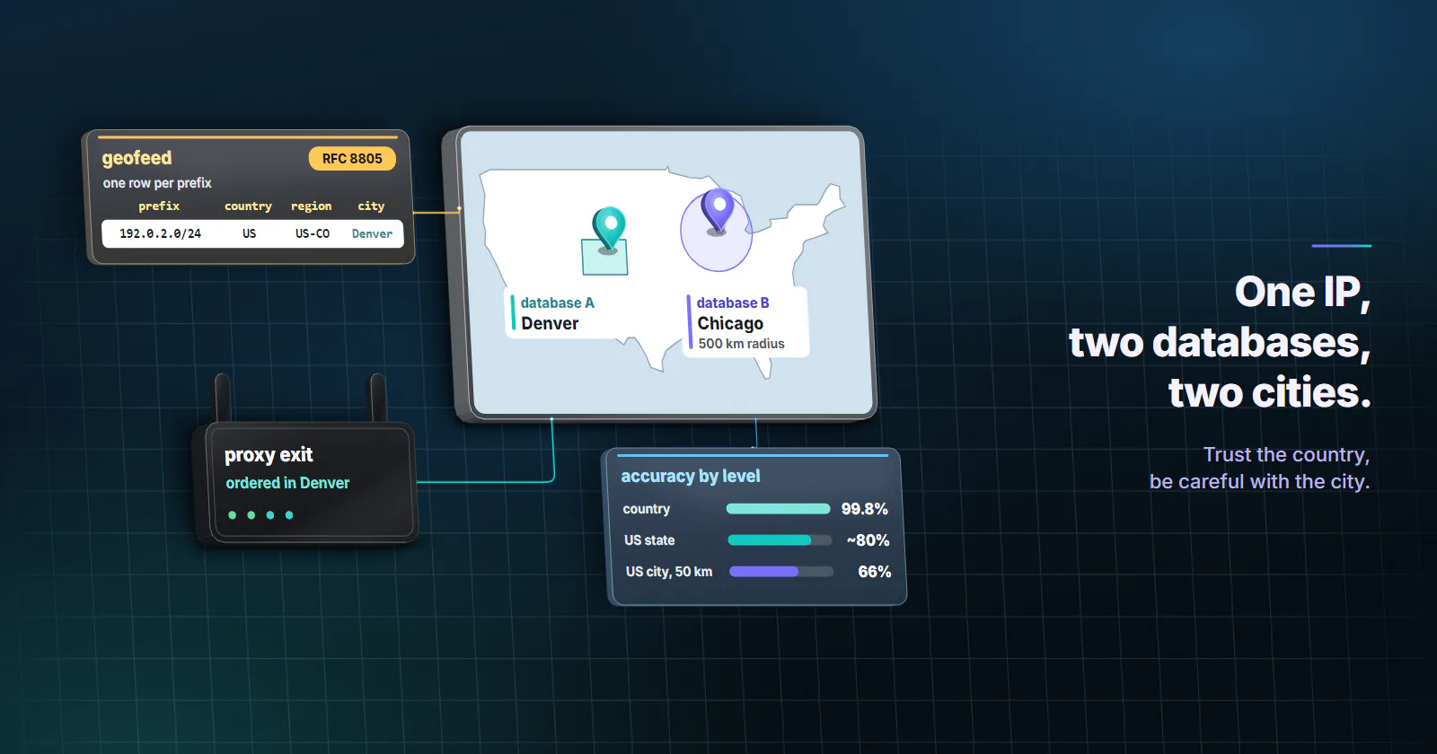
- Trust the country, be careful with the city. MaxMind puts its own country accuracy at 99.8% but only 66% for US cities within 50 km (checked October 2026), so a city label that is off by one suburb is normal, not a bug.
- Two lookup sites, two cities is the usual case. Each database mixes registry records, operator geofeeds, latency probes and its own data, and stores ranges of different sizes, so they split at city level all the time.
- Mobile is the weak spot. A 2026 study of four providers found median mobile errors of 179-207 km, so an empty
cityon a carrier address is expected, and region is the level worth reading. - The target's database is the one that counts. If the exit is right and the page is still wrong, check DNS first: plain socks5:// resolves on your machine, which is the annoying one to spot.
IP geolocation accuracy is high for countries and much lower for cities. MaxMind estimates 99.8% at country level, around 80% for US states and 66% for US cities within 50 km. Two databases can place one IP in different cities, mobile addresses are the weakest case, and every website runs its own lookup, so the label you see is one estimate among several.
So if an IP checker just put you, or a proxy exit you ordered in Denver, two states away, nothing is necessarily broken. An IP address carries no coordinates. Somebody guessed, and the site you care about may have guessed differently.
That gap is where most “why is my IP location wrong” tickets come from, and it is easy to waste an afternoon on it. What follows is where the guesses come from, why they split, what fixes them, and a short script that tells you how far to trust the city label on your own exits.
IP geolocation accuracy by level
Vendors publish their own numbers, and they are honest about how fast precision falls off. MaxMind’s accuracy notes (checked October 2026) give 99.8% at country level, about 80% at state or region level for US IPs, and 66% for US cities, where “right” means within 50 km of the true city. It also says accuracy varies by country, by IPv4 versus IPv6 and by cellular versus broadband.
Read the city figure carefully. About a third of US lookups do not land within 50 km, and 50 km is already the distance from one end of a metro area to the other. MaxMind’s own per-country accuracy table (checked October 2026) splits the US result further: a share correct within 50 km, a share placed in a city outside that radius, and a small share with no city at all. That last group is the one people misread as a broken lookup. And the table moves a long way from one country to the next, so a US figure tells you little about Brazil or India.
The accuracy radius. City-level lookups in MaxMind’s databases return an accuracy_radius in kilometres next to the coordinates. It is the honest part of the answer. A Chicago label with a 500 km radius means “somewhere in the Midwest”, and if your code only reads city.name, it throws that warning away.
How an IP location database builds a location
No IP location database watches devices. Each one stitches a location together for a block of addresses from a few inputs, weighted its own way, and no vendor publishes the full recipe.
Registry records. Regional internet registries hold who an address block is assigned to and where that organisation says it is. A 2020 APNIC study of geolocation services (published September 15, 2020) found the databases it tested lean on these WHOIS fields, and that organisations with an international presence are often placed in the wrong country. A company registered in Amsterdam with offices in six countries looks Dutch everywhere.
Operator feeds. Whoever runs the block can publish where its prefixes are used, in a geofeed (next section).
Latency measurement. Ping times from known vantage points narrow down where a router sits. Light in fibre covers roughly 100 km per millisecond of round trip, so a fast reply from a probe in Frankfurt rules out Sydney. It is coarse at city level and expensive to run everywhere.
Partner and usage data. Vendors also fold in correction reports and other signals they do not publish. This is the part that differs most between vendors, and the part you cannot audit.
Geofeeds: RFC 8805 and RFC 9632
Think of a geofeed as a CSV that a network operator publishes to say where its address ranges are used. RFC 8805 (August 2020) fixes the format: one row per prefix, with a country code, an ISO 3166-2 region and a free-text city. Postal codes survive only as a deprecated field. RFC 9632 (August 2024, replacing RFC 9092) says how a database finds the file: a geofeed: attribute, or a remarks: line, on the registry’s inetnum object points to an HTTPS URL, the most specific object wins, and rows outside that object’s range are ignored.
So a wrong city is often the operator’s doing rather than the IP checker’s, and the checker is faithfully repeating what the network told it.
Why geolocation databases disagree
Paste one IP into three lookup sites and you will often get one country and two or three cities. That geoip mismatch is the everyday face of IP geolocation accuracy, and its causes are ordinary.
Different inputs, different weights. One vendor trusts the geofeed, another overrides it with latency data, a third has a correction report the others never received. None of them is wrong by its own rules.
Different block sizes. Databases store ranges, not single addresses. If one vendor maps a /16 to one city and another splits it into /24s, every address in that /16 gets two answers.
A city label is a representative city. When the estimate is an area, many databases name its largest or most central city. Your town of 8,000 becomes the hub city 40 km away, and on a map that looks like an error.
How often IP databases are updated
Every vendor ships on its own schedule. MaxMind’s 2022 release notes moved its free GeoLite databases to twice-weekly updates, and the paid ones ship on their own cadence. Then each website loads a new file whenever its own team gets round to it, which can be weeks later. So a block that moved last month can be right on one checker and stale on the site you actually care about.
Why your IP location is wrong
The classic causes, in rough order of how often they turn out to be the answer:
- Your ISP’s hub city. Traffic from smaller towns often leaves through a regional point of presence, and the block is registered there. This is the most common one, and the least fixable from your side.
- A reassigned or reused block. Addresses move between ISPs and regions, dynamic home lines pick up a new address from the ISP’s pool now and then, and IPv6 ranges are a separate accuracy factor on MaxMind’s own list. Until every database catches up, the old location sticks.
- A VPN or proxy. The site sees the exit, so it locates the exit. Obvious once you remember the extension you turned on last week.
- The site is not using IP at all. A saved delivery address, the browser’s
navigator.language, the time zone fromIntl.DateTimeFormat().resolvedOptions().timeZone, or the Geolocation API (which asks permission first) can each override the IP label. Worth ruling out before you blame the database.
Mobile and CGNAT accuracy
Mobile is where a precise city label falls apart. Carriers put many subscribers behind shared addresses (CGNAT) and route them through a few gateways, so one block can serve a whole state. MaxMind says that when a mobile address covers a whole US state, it stores the country and state and leaves the city empty.
Independent research puts a number on it. “Lost in the Prefix” (arXiv, May 2026) tested four geolocation providers on 37,302 observations in 175 countries and found median mobile errors between 179 and 207 km, more than ten times the fixed-network figure, with about 70% of mobile prefixes spanning more than 100 km. All four providers landed close together, which points at how carriers address their networks rather than at any one vendor. A missing city on a mobile exit is expected behaviour, not a fault.
Proxy wrong location: what to check
Through a proxy, the question changes from “where am I” to “where does the target think the exit is”. Your provider assigns an exit in the location you ordered; the target then places that exit again with whatever database it licenses. On proxymint, residential and mobile proxies take a country, region and city on the order, picked from locations with devices online at that moment, and a live order can move to another location later. Static ISP and datacenter IPv4 are chosen by country.
When a geo-sensitive page comes back wrong, match the symptom before you touch the order:
| What you see | Likely cause | Check |
|---|---|---|
| Right country, wrong city on one checker | The databases disagree at city level | Look the exit up in a second database and read the accuracy radius |
| City empty, state right | Mobile or CGNAT block mapped only to the state | Expected on carrier addresses; target region if the page varies by state |
| Exit IP correct, page shows your home country | DNS resolved on your machine, so a CDN answered for your location | Use an http:// or socks5h:// proxy URL instead of socks5:// |
| Exit and DNS correct, page still local to you | Account address, cookies, language or time zone | Fresh browser profile with locale and time zone set for the market |
| Every checker agrees, one site disagrees | That site’s database is stale or uses another vendor | Nothing on your side fixes it; test the exact page you need |
The DNS row is the sneaky one. In proxymint Lab #1 (measured September 28, 2026), HTTP CONNECT and socks5h:// resolved target names on the proxy side, while plain socks5:// sent every lookup through the client’s own resolver, in another country. So the exit was right and the page was still wrong. Fixing it takes one letter in the proxy URL, and the DNS leak guide has the client-by-client detail.
Measure geolocation accuracy on proxy exits
A vendor’s 66% is an average over everyone. For your job, the number that counts is how often two databases agree on the exits you actually get, at the level you ordered. That check takes a few minutes and makes the IP geolocation accuracy question concrete.
Here is the method. Rotate through 200 exits at one ordered location, look each up twice (an echo service through the proxy, plus a local MaxMind GeoLite2 City file, which needs a free account), and record country, region and city agreement against the order and against each other.
import math, requests, geoip2.database  # pip install requests geoip2
from urllib.parse import quote

USER, PASS = "USERNAME", "PASSWORD"
PROXY = f"http://{quote(USER, safe='')}:{quote(PASS, safe='')}@HOST:PORT"
ORDERED = {"country": "US", "region": "Colorado", "city": "Denver"}
N = 200

def km(a, b):
    la1, lo1, la2, lo2 = map(math.radians, (*a, *b))
    h = math.sin((la2 - la1) / 2) ** 2 + math.cos(la1) * math.cos(la2) * math.sin((lo2 - lo1) / 2) ** 2
    return 12742 * math.asin(math.sqrt(h))

hits = {"country": 0, "region": 0, "city": 0, "within_50km": 0}
seen = set()
with geoip2.database.Reader("GeoLite2-City.mmdb") as db:
    for _ in range(N):
        e = requests.get("https://ipinfo.io/json", timeout=20,
                         proxies={"http": PROXY, "https": PROXY}).json()
        if e["ip"] in seen:
            continue
        seen.add(e["ip"])
        m = db.city(e["ip"])
        hits["country"] += e.get("country") == m.country.iso_code == ORDERED["country"]
        hits["region"] += e.get("region") == m.subdivisions.most_specific.name == ORDERED["region"]
        hits["city"] += e.get("city") == m.city.name == ORDERED["city"]
        if e.get("loc") and m.location.latitude is not None:
            a = tuple(map(float, e["loc"].split(",")))
            hits["within_50km"] += 50 >= km(a, (m.location.latitude, m.location.longitude))

print(f"unique exits: {len(seen)}")
for k, v in hits.items():
    print(f"{k:12} {v}/{len(seen)}")
Set rotation to every request on the order so each call draws a new exit. Expect country agreement near the top, a visible drop at region, and the real spread at city. Run it at two different hours, because the exits online change with the time of day.
Treat the result as a fit check. If both databases agree on the city for most exits, city targeting is doing what the job needs. If city agreement is low but region holds, the page probably varies by region anyway, and geo targeted proxies walks through when region is the better level. And when the agreement looks fine but the site still serves the wrong page, go back to the table above: the cause is usually DNS or the browser.
Correct a wrong IP location
Better IP geolocation accuracy for one address only comes from the people who hold the data, so who can fix it depends on whose address it is.
Your own home or office line. The network operator is the root fix: ask your ISP whether it publishes a geofeed and whether your block is in it. Then file corrections with the big databases directly. MaxMind, IPinfo and others each run a correction form, and each fix lands in one database only, then waits for every site to download the new file. Treat it as weeks, not hours.
A server or network you run. Publish a geofeed under RFC 8805 and reference it from your inetnum object under RFC 9632. One file then updates every database that reads geofeeds on its next pass, which beats filing ten forms.
A proxy exit. You do not own the address, so correcting it is not your job, and the target’s database is not something any provider controls. What you control is the order: target the level the page really varies by, set the browser for the market, resolve DNS at the proxy, and check the exact page before the run. For a store or delivery site that asks for a postcode, entering it in the site usually beats any IP label.
Which level your job can trust
Use the IP geolocation accuracy numbers as a guide to which level to rely on, not as a promise about any single address.
- Country decides the page (national prices, legal notices, most catalogs): any database agrees, and country targeting keeps the deepest pool of exits.
- State or region decides it (tax, shipping zones, regional ads): target region, and look up a sample of exits in two databases before the run.
- City decides it (local search results, store availability, city ad markets): target city on home broadband exits, run the two-database check above, and measure against the target’s own page, because its database has the final word.
- The job needs a mobile origin: expect state-level labels and treat city as a bonus.
For home-broadband exits placed by country, region and city, rotating residential proxies are the tier built for location-dependent monitoring, with rotation per request, on a timer or sticky.
Frequently asked questions
Very accurate for countries and much less for cities. MaxMind estimates 99.8% accuracy at country level, about 80% at state level for US IPs and 66% for US cities within 50 km. Accuracy also drops on mobile networks, where one address block can cover a whole state.
Usually because the database maps your address block to your ISP's regional hub city, the block was recently reassigned, or a VPN or proxy is on. Some sites also ignore the IP and use a saved address, browser language or time zone instead, so check those before blaming the lookup.
Each site uses a different geolocation database, and each database weighs registry records, operator geofeeds, latency measurements and its own data differently. They also store address ranges at different sizes and update on different schedules. At country level they almost always agree; at city level a split is routine.
No. An IP address carries no coordinates, and databases estimate a location for a whole block of addresses, usually to a city or region with a radius of tens to hundreds of kilometres. A street address comes from GPS, a shared location or an account, not from the IP.
Ask your ISP whether it publishes a geofeed that covers your block, since that file feeds many databases at once. Then file a correction with the major databases, such as MaxMind and IPinfo, through their correction forms. Each fix reaches one database and then waits for websites to load the new file, which can take weeks.
A geofeed is a CSV file a network operator publishes to say where its address ranges are used: one row per prefix with a country, a region and a city. RFC 8805 defines the format and RFC 9632 explains how databases find it through the registry record. It is a claim by the operator, so databases validate it before trusting it.
The target runs its own geolocation lookup on the exit IP, and its database may disagree with the one your checker uses, especially at city level. If the IP looks right but the page is local to you, DNS is often resolving on your machine over plain socks5, or the browser language, time zone or a saved account address is overriding the IP.
Researched and drafted with AI tools, then checked against our publishing rules before it went live: 7 outside links, 6 links to other proxymint pages, no prices and a fact-check pass against our product records. How we write.